By Sean Ryan
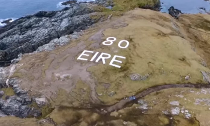
Around Ireland’s coastline are a group of signs which are immediately striking to the eye from mid-air. They relate to the Second World War in Ireland during the period of Ireland’s neutrality and were put in place to ensure the country was spared the ravages of war.
In 1939, a Coastal Watch was set up to guard against the invasion of Ireland. Eighty-three sites were chosen around the coast, from North County Louth to Inishowen in Donegal, and Look Out Posts (LOPs) were established on these sites, with a team of watchmen, who were usually locals. According to ÉireMarkings.org, watchmen were initially housed in tents, but eventually a standard pill box was erected at each site.
The sites were numbered, with number 1 being located in Ballagan Point, County Louth, and number 82 on Inishowen Head, County Donegal. Foileye Head Kerry was no. 83.
From 1942-1943, the Éire signs, or Neutrality Signs, were added along the coast to alert pilots to their location. Shortly after the Éire signs were erected, the identifying number of the LOP was added, thereby enhancing the sign’s value as a navigational aid. A list of LOPs was given to allied pilots to reduce the risk of them crashing in the Republic of Ireland and to give them greater detail on their location.
The signs were useful only during the day, but fires may have been lit near the signs at night. Eight of the signs can still be seen on headlands in Donegal, where the greatest number of them have survived. Three of these are still visible on the Inishowen Peninsula: No. 80 Malin Head, No. 81 Glengad Head and No. 82 Inishowen Head.
In 2018 a sign dating from World War II was uncovered and was fully restored on a cliffside in Dalkey, south Dublin. The Éire sign, was discovered following research involving members of the Dalkey Tidy Towns Committee. Nothing like this has been done elsewhere in Ireland. None of the ‘Éire’ signs have been comprehensively studied, excavated and restored like this to wartime condition,” claims Michael Kennedy, historian at the Royal Irish Academy, who has mentored Dalkey Tidy Towns’ ambitious project as historical adviser. Mr Kennedy, who is the author of the book ‘Guarding Neutral Ireland,’ told the Irish Times newspaper “This was the border of the war, at the frontline of our defence, during a period of hostile threat to Ireland.”
It fits, he says, into “a wider-geopolitical perspective behind the signs, which runs from neutral Ireland’s frontline soldiers, via the US embassy – which requested the construction of the ‘Éire’ signs – to Eisenhower’s plans for D-Day.”
The Dalkey sign which is located some eight miles up the coast from the city, took a number of years to find. For about five years both Michael Kennedy and Des Burke-Kennedy from Dalkey Tidy Town were on the lookout. “You’re looking at the landscape for a sign – it’s got to be there somewhere.” The breakthrough came in autumn 2018 when local woman Orla de Cogan showed Burke-Kennedy an aerial black and white 1940s-50s photograph of the area that hung in her parents’ house for years.
Looking closely, there was a hint of what could have been letters at Hawk Cliff. It was somewhere to start, and they set out with spade and archaeology stick, poking at the ground. Amazingly, they found stones on day one. They were part of the letter “R”.
Des Burke-Kennedy of Dalkey Tidy Towns told RTÉ “We started with the letter ‘R’ and very soon we could see the shape emerging.” A team of up to 35 volunteers met once a week for almost six months, painstakingly clearing the site, lifting and cleaning 100 tonnes of stones, before laying weed killer and returning them. Roadstone supplied four tonnes of a binding agent which was added to the stones to prevent their removal. “We thought we were finished then, but we still had to paint the stones,” Des said.
He added “We contacted a company called Sika. They make paint for lighthouses – that has to be good enough for us.” Another mammoth community effort ensued to paint the 20ft letters which now shine bright on the Dalkey coastline. “It’s lucky we don’t live in Switzerland,” he laughs.
Today, most of the “Éire” signs have been covered by the landscape, and only five or so are clearly visible from the air, including Loop Head and Malin Head. Thankfully, thanks to the work of the Dalkey volunteers, the sign is now more than visible.


